
The Nile River is the longest river in Africa and the entire world at large. Nicknamed “The Father of African Rivers”,
The longest drainage system on the planet rises from South of the Equator, leaving Lake Victoria at Falls near Jinja Uganda, flowing northwards Africa to drain into the Mediterranean Sea.

The Nile River flows a distance of about 4,132 miles (6,650 kilometers) and drains an area estimated at 1,299,000 square miles (3,349,000 square kilometers). Along its course, The Nile flows an average volume of 300 million cubic meters (79.2 billion gallons) of water per day. This is according to Travel Along Rivers, a Dutch bilingual travel magazine.
From the tropical climate of Eastern Africa, flowing northwards into the Mediterranean Sea, The Nile River passes through 11 countries; Tanzania, Uganda, Rwanda, Burundi, The Democratic Republic of Congo, Kenya, Ethiopia, Eritrea, South Sudan, Sudan, and Egypt.
Read: Who Owns the Nile? Egypt, Sudan, and Ethiopia’s History-Changing Dam
The Nile River delta.
The Nile is formed by three principal streams; The Blue Nile and the Atbara which flows from the highlands of Ethiopia and the White Nile, the headstream which flows into Lakes Victoria and Albert.
However, The Nile River has two major tributaries; The Blue Nile and The White Nile. Traditionally, The White Nile is considered to be the headward stream. Nevertheless, The Blue Nile is the source of most of the water to The Nile downstream, containing 80% of the water and silt. The Blue Nile and The White Nile meet the Sudanese capital, Khartoum.
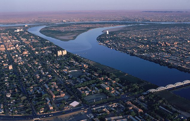
The Nile River delta itself is approximately 100 miles (161 kilometers) long from north to south, and spreads out along about 150 miles (241 kilometers) of the Egyptian coastline; from Alexandria in the west to Port Said in the east. This makes it one of the world’s largest river deltas with about 400 million inhabitants: approximately half of Egypt’s population.
Right before reaching the Mediterranean Sea, the river splits into two main branches, the Rosetta branch (to the west) and the Domietta branch (to the east).
History of The Nile River.
Perhaps, no river on earth has captured human imagination quite well like The Nile River. From stones of Rhercos and man-eating crocodiles to the discovery of the Rosetta stone, it was here along the river’s fertile lands that one of the world’s renowned civilizations, “Ancient Egypt” was born, around 3000 B.C. The Nile was not only the source of life for the ancient Egyptians but is still today for the modern people living along its banks.
Read: The Amazon River; What You Need To Know About World’s Largest River
Known as both the “Father of Life” and “Mother of All Men”, The Nile River was the center of life in Ancient Egypt. The Ancient Egyptians also called the river ‘Ar’ or ‘Aur’, which means “black”, in reference to the black silt left behind after the yearly flooding.
The Nile is also associated with many gods and goddesses, all of whom the Egyptians believed were deeply intertwined with the blessings and curses of the land, weather, culture, and abundance of the people. They believed that gods were intimately involved with the people and could help them in all factors of their lives.
Climate in the Nile River Basin.
Almost no area within the Nile basin experiences a true equatorial or a true Mediterranean type of climate. While the Nile basin in Sudan and Egypt is rainless during the northern winter, its southern parts and the highlands of Ethiopia experience heavy rain—more than 60 inches (1,520 millimeters)—during the northern summer. Most of the region falls under the influence of the northeast trade winds between October and May, which causes the prevailing aridity of most of the basin.
Tropical climates with well-distributed rainfall are found in parts of the East African lakes region and southwestern Ethiopia. In the lake region, there is little variation throughout the year in the mean temperature, which ranges from 60 to 80 °F (16 to 27 °C) depending on locality and altitude. Relative humidity, which varies similarly, is about 80 percent on average.
Similar climatic conditions prevail over the western and southern parts of South Sudan, which receive as much as 50 inches of rain spread over a nine-month period (March to November), the maximum occurring in August. The humidity reaches its highest at the peak of the rainy season and reaches its low level between January and March. Maximum temperatures are recorded during the dry season (December to February), and minimums occur in July and August.
To the north, the rainy season gets shorter, and the amount of rainfall decreases. The rainy season, which occurs in the south from April to October, is confined to July and August in south-central Sudan, where three seasons may be distinguished. The first of these is the pleasant, cool, dry winter, which occurs from December to February; this is followed by hot and very dry weather from March to June; and this is followed, in turn, by a hot rainy period from July to October. The minimum temperature occurs in January and the maximum in May or June when it rises to a daily average of 105 °F (41 °C) in Khartoum. Only about 10 inches of rainfall occurs annually.
Life in The Nile River Basin.
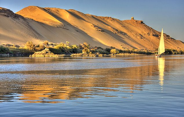
The soil of the Nile River delta between El Qâhira (Cairo) and the Mediterranean Sea is rich in nutrients, due to the large silt deposits the Nile leaves behind as it flows into the sea. The banks of the Nile all along its vast length contain rich soil as well, thanks to annual flooding that deposits silt. From space, the contrast between the Nile’s lush green river banks and the barren desert through which it flows is obvious.
For millennia, much of Egypt’s food has been cultivated in the Nile Delta region. Ancient Egyptians developed irrigation methods to increase the amount of land they could use for crops and support a thriving population. Beans, cotton, wheat, and flax were important and abundant crops that could be easily stored and traded.
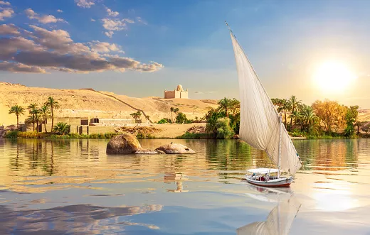
The Nile River Delta was also an ideal growing location for the papyrus plant. Ancient Egyptians used the papyrus plant in many ways, such as making cloth, boxes, and rope, but by far its most important use was in making paper. Besides using the river’s natural resources for themselves and trading them with others, early Egyptians also used the river for bathing, drinking, recreation, and transportation.
Today, 95 percent of Egyptians live within a few kilometers of the Nile. Canals bring water from the Nile to irrigate farms and support cities. The Nile supports agriculture and fishing. The Nile also has served as an important transportation route for thousands of years. Today, some residents of El Qâhira (Cairo) have begun using private speed boats, water taxis, or ferries to avoid crowded streets. Dams, such as the Aswân High Dam in Egypt, have been built to help to tame the river and provide a source of hydroelectric power.
Flooding of The Nile River.
The flooding of the Nile River has been an important natural cycle in Egypt since ancient times. It is a phenomenon celebrated by Egyptians as an annual holiday for two weeks, in August 15, known as Wafaa El-Nil. It is also celebrated in the Coptic church by ceremoniously throwing a martyr’s relic into the river, hence the name, The Matyr’s Finger.
The flooding of The Nile was poetically described in myths as Isis’ tears of sorrow for Osiris when he was killed by his brother Set.
Yearly, monsoons between May and August cause enormous precipitations on the Ethiopian Highlands whose summits reach heights of up to 4,550 m (14,930 ft). Most of this rainwater is taken by the Blue Nile and by the Atbarah River into the Nile, while a less important amount flows through the Sobat and the White Nile into the Nile. During this short period, those rivers contribute up to ninety percent of the water of the Nile and most of the sedimentation carried by it, but after the rainy season, dwindle to minor rivers.
The flooding as such was foreseeable, though its exact dates and levels could only be forecast on a short-term basis by transmitting the gauge readings at Aswan to the lower parts of the kingdom where the data had to be converted to the local circumstances. What was not foreseeable, of course, was the extent of flooding and its total discharge.
The Egyptian year was divided into three seasons Akhet (Inundation), Peret (Growth), and Shemu (Harvest). Akhet covered the Egyptian flood cycle. This cycle was so consistent that the Egyptians timed its onset using the heliacal rising of Sirius, the key event used to set their calendar.
The Nile – Home to a Crocodile god and a Crocodile city.
As ancient Egypt grew along the Lower Nile, the river’s importance was not lost on its people, who made it a central theme of their society. Ancient Egyptians knew the Nile as Ḥ’pī or Iteru, meaning simply “river,” but it was also called Ar or Aur, meaning “black,” in honor of its life-giving mud. They correctly saw it as their source of life, and it played a key role in many of their most important myths.
The Milky Way was seen as a celestial mirror of the Nile, for example, and the sun god Ra was believed to drive his ship across it. It was thought to embody the god Hapi, who blessed the land with life, as well as Ma’at, who represented the concepts of truth, harmony, and balance, according to the AHE. It was also associated with Hathor, a goddess of the sky, women, fertility, and love.

In one popular myth, the god Osiris is betrayed by his jealous brother Set, who tricks him into lying down in a sarcophagus, pretending it’s a gift. Set the traps Osiris inside and throws him in the Nile, which carries him away to Byblos. Osiris’ body is eventually found by his wife, Isis, who retrieves him and tries to bring him back to life.
Set intervenes, though, stealing Osiris’ body, chopping it into pieces, and scattering them across Egypt. Isis still tracks down every piece of Osiris — all except for his penis, which had been eaten by a Nile crocodile. That’s why crocodiles were associated with the god of fertility, Sobek, the AHE explains, and this event was seen as the catalyst that made the Nile so fertile. Due to this story, the AHE adds, anyone eaten by a crocodile in ancient Egypt “was considered fortunate in a happy death.”
The reverence for Nile crocodiles was particularly strong in the ancient city of Shedet (now called Faiyum), located in the river’s Faiyum Oasis south of Cairo. This city was known to the Greeks as “Crocodilopolis,” since its residents not only worshipped Sobek but also honored an earthly manifestation of the god: a living crocodile named “Petsuchos,” whom they covered in jewelry and kept in a temple, according to The Guardian. When one Petsuchos died, a new crocodile filled the role.
The Nile River Basin has been changing over the years.
People have left their mark along the Nile for millennia, but the dynamic has changed a bit lately. One big shift came in 1970 with the completion of the Aswan High Dam, which impounds the river in southern Egypt to create a reservoir called Lake Nasser. For the first time in history, this gave humans control over the Nile’s life-giving floods. Today, it benefits Egypt’s economy as water can now be released where and when it’s needed most, and since the dam’s 12 turbines can generate 2.1 gigawatts of electricity.
The dam has also changed the Nile in negative ways, however. The black silt that tamed the Sahara, for example, is now largely impounded behind the dam, accumulating in the reservoir and canals instead of flowing north. Silt used to enrich and expand the Nile Delta over time, but it’s now shrinking due to erosion along the Mediterranean coast.
The dam has also led to a gradual decline in the fertility and productivity of riverside farmland, Britannica adds, noting that “Egypt’s annual application of about 1 million tons of artificial fertilizers is an inadequate substitute for the 40 million tons of silt formerly deposited annually by the Nile flood.” Offshore from the delta, fish populations have reportedly declined due to loss of nutrients once delivered by Nile silt.
Sudan also has some older dams along Nile tributaries, like the Blue Nile’s Sennar Dam, which opened in 1925, or the Atbara’s Khashm el-Girba Dam, which opened in 1964. These may not alter the river quite like the Aswan High Dam, but a project in Ethiopia has raised new fears over water supplies downstream.
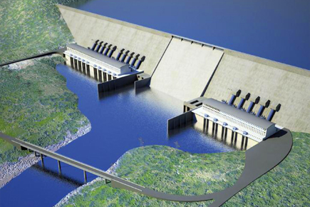
Located on the Blue Nile, the $5 billion Grand Ethiopian Renaissance Dam (GERD) has been under construction since 2011 and is expected to generate 6.45 gigawatts once it’s fully operational in 2022. That could make a huge difference for Ethiopia, where about 75% of people lack access to electricity, and selling excess electricity to nearby countries could reportedly bring the country $1 billion per year.
To deliver those benefits, however, the dam will need to hold back lots of water that would otherwise flow to Sudan and Egypt. That has stirred anxiety in those countries, both of which are already prone to water shortages, given the scale of the project. The dam will create a reservoir more than double the size of Lake Mead — the largest reservoir in the U.S., held behind the Hoover Dam — and will eventually hold 74 billion cubic feet of water from the Blue Nile, according to Yale Environment 360. Filling the reservoir could take anywhere from five to 15 years.
“During this period of fill, the Nile’s freshwater flow to Egypt may be cut by 25%, with a loss of a third of the electricity generated by the Aswan High Dam,” researchers reported in GSA Today, a journal published by the Geological Society of America. Many in Egypt worry the dam will also limit water supplies long after the reservoir is filled, compounding other problems related to population growth, water pollution, land subsidence, and climate change, along with the ongoing loss of silt at Aswan.
Egypt, Ethiopia, and Sudan have made little progress despite nearly a decade of on-and-off negotiations, although they did reach an initial deal at a January 2020 meeting. That was a breakthrough in the long-running dispute and the three countries are now holding follow-up talks in hopes of finally solidifying a “comprehensive, cooperative and sustainable agreement.”
Fun fact; The Ancient Egyptians planned their calendar around The Nile and the stars. The year began in mid-July when the river began to rise for annual flooding.